On October 29th, 2012, Hurricane Sandy made landfall on the coast of southern New Jersey as a hurricane force “post tropical cyclone”. While she may not have met the technical definition of a true hurricane, her impacts were just as severe, and sadly took more than 100 lives.
Hurricane Sandy was a category 1 hurricane as it approached the coast, with winds of 90mph sustained, gusting over 100mph. Given its massive size, high winds, storm surge, and flooding were already occurring not only at the coast, but inland well before landfall.
How large was Sandy? Just before landfall, hurricane force winds extended out 175 miles from the center, an tropical storm force winds extended out more than 480 miles from the center, making it the largest Atlantic hurricane on record. Her total width was estimated at more than 1,000 miles across!
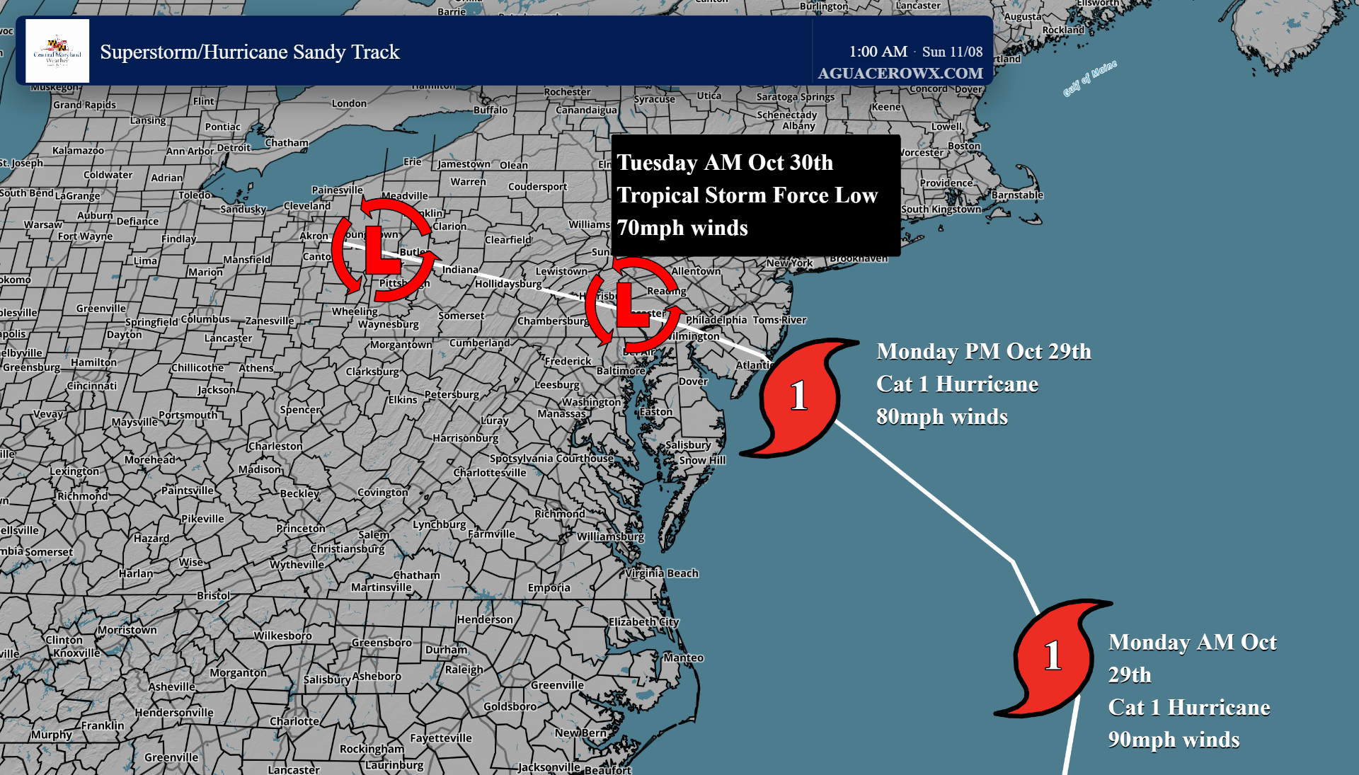
Estimated track of Sandy from Monday October 29th through Tuesday October 30th
WINDS
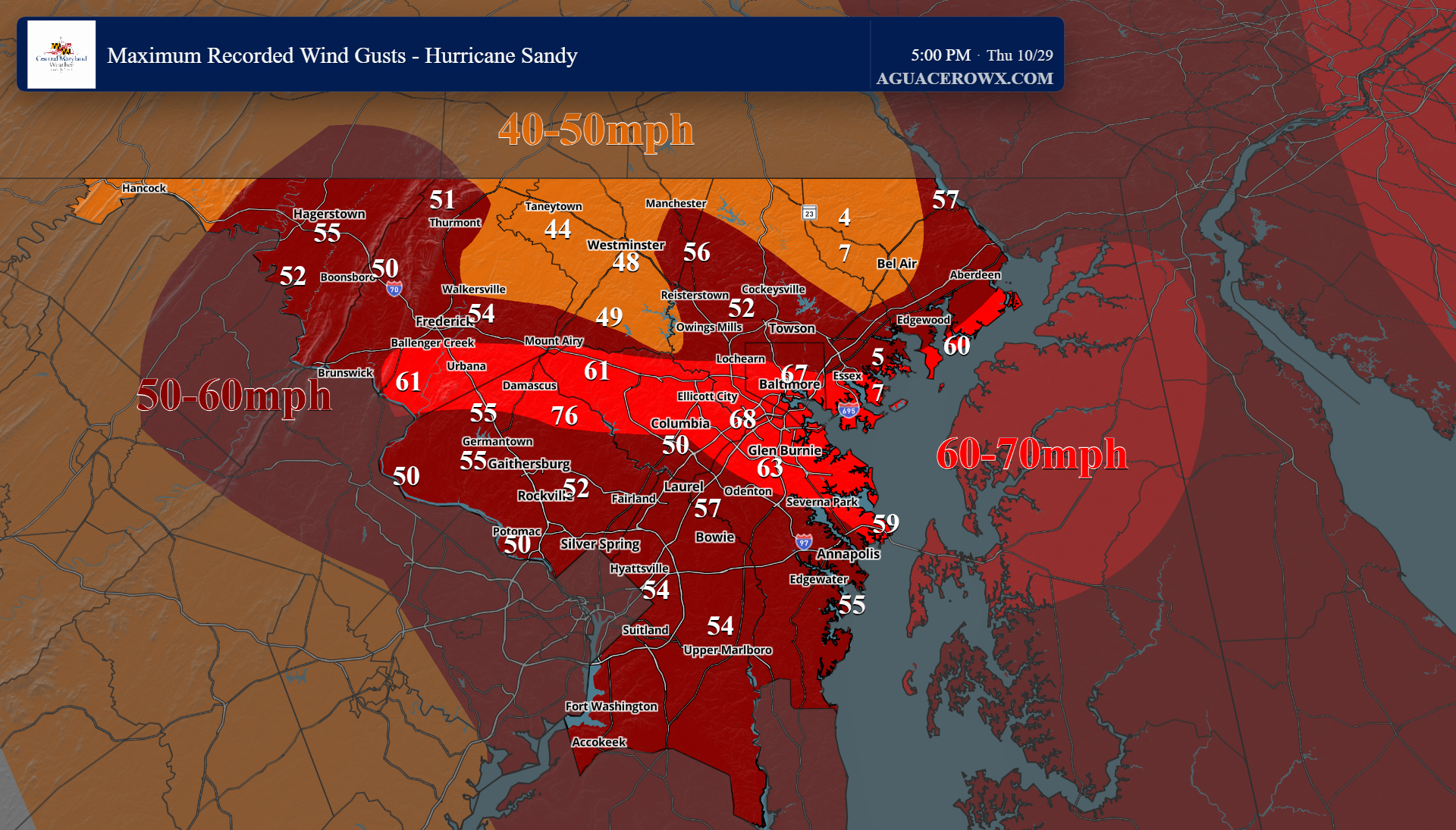
Sandys winds were fierce, with sustained winds upon landfall equivalent to a category 1 hurricane at 80mph, with stronger gusts. Widespread, long duration wind gusts of 50-65mph were common across central Maryland, with pockets of gusts exceeding 75mph (hurricane force) as well. This blew down thousands of trees and powerlines, damaged homes and businesses, and knocked out power to hundreds of thousands of Marylanders.
Some of the highest wind gusts:
Laytonsville - 76mph
Halethorpe - 68mph
Baltimore - 67mph
Ellicott City - 63mph
BWI Airport - 63mph
Lisbon - 61mph
Adamstown - 61mph
Annapolis - 59mph
Essex - 57mph
Hargerstown - 55mph
Germantown - 55mph
Rain/Flooding
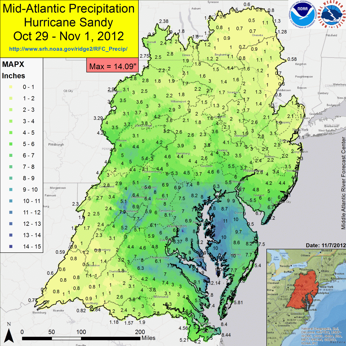
Sandy produced a tremendous amount of rain with widespread freshwater flooding and flash flooding across Maryland. Rainfall totals of 5-8” were common, but a few places approached 1 foot. Widespread flooding occured, including numerous road closures. Some of the roads that were closed included MD 103 in Howard county, Crow Rock Road in Frederick County, MD 542 in Baltimore county, and US 29 in Montgomery county, just to name a few.
Additionally, the widespread and prolonged heavy rain resulted in many rivers overflowing their banks, reaching moderate to even major flood stage. The Monocacy river in Frederick reached a crest of 21.78 feet, which exceeds major flood stage. Seneca Creek in Dawsonville (Montgomery County) reached moderate flood stage, cresting at 11.13 feet, with the Potomac River at Little falls and Point of Rocks both cresting above minor flood stage.
Highest Rain Totals:
Urbana - 8”
Towson - 8.2”
Germantown - 8.1”
Essex - 8”
Columbia - 7”
Bethesda - 7”
Hagerstown - 5.6”
Thurmont - 6.9”
Frederick - 6.1”
Storm Surge
While not as significant as Isabel in 2003, Sandy produced significant storm surge and coastal flooding along the western shore of the Chesapeake Bay, slightly exceeding expectations.
Highest Surge Reports:
Baltimore - 3.69 feet above normal tide level
Annapolis - 3.35 feet above normal tide level
Washington D.C. - 4.03 feet above normal tide level
Why no hurricane warning:
As Sandy approached, she began loosing her tropical characteristics, and developed more into a Nor Easter type storm. This meant that the National Hurricane Center couldn’t (or wouldn’t) issue hurricane warnings for the Mid Atlantic and northeast, despite a forecasted direct hit.
People in the path did not take Sandy as seriously as they should have since no hurricane warnings were issued. High wind warnings were in effect, but those do not trigger WEA/wireless emergency alerts like a hurricane warning does. Additionally, we get high wind events regularly in the northeast, but this was not your ordinary high wind event.
It is believed that the lack of hurricane warnings was a contributing factor in the number of fatalities and lack of evacuations, or delayed evacuations. Had hurricane warnings been issued (simply due to the hurricane-like impacts), evacuations may have begun earlier, and residents would likely have taken the storm more seriously.
Sandy resulted in a huge learning curve for all of us, including residents, broadcast meteorologists, emergency managers, government officials, and the National Hurricane Center (which can now issue hurricane warnings for hurricane force post tropical cyclones like Sandy).
