OTD in 2018: catastrophic flash flood roars through ellicott city and catonsville
On the afternoon of May 27th 2018, multiple rounds of extremely heavy rain yet again tracked over central Howard county. These thunderstorms came after an already wet start to the year, with the area already primed for flooding. This was a fairly well forecasted event with a flash flood watch being issued earlier that morning many hours ahead of the rain. At 3:19pm, things began to rapidly worsen with a flood warning being issued. In total, over 1,100 911 calls were reported across Howard County due to flooding or storm damage.
As a former Ellicott City resident, this day always brings back the memories of the aftermath. Seeing overturned and destroyed cars, flood lines FEET above the floors of buildings on Main Street, etc. I was not home at the time. I did not live on Main street, but I lived about 8 minutes away. I was at Michaels with my mom, and we watched the flooding on a live camera on our phones with several other patrons in the store after our phones were triggered by WEA. It was a terrifying scene to see live.
Round 1 of Storms/Flooding
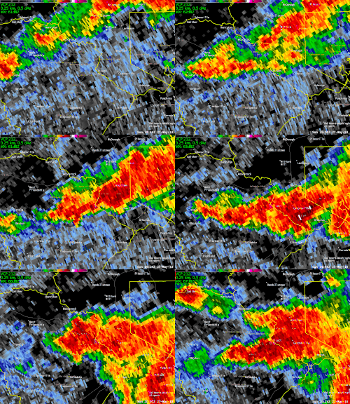
This is a radar timelapse of the multiple rounds of storms that passed directly over Ellicott City and Catonsville, kick starting the flash flood event. Sadly, this was just the first round, with another, more intense round forthcoming.
The previously issued flood warning was upgraded to a flash flood warning, and eventually a flash flood emergency as reports of catastrophic flooding came in. The NWS issued a statement with bone chilling wording to stress the life or death situation unfolding in Old Ellicott City and Catonsville:
"At 538 PM EDT, there have been numerous reports of significant flash flooding, roads flooded, streams flooded, and flood damage throughout the area. HEAVY RAIN HAS MOVED BACK INTO THIS AREA. THOSE CURRENTLY RESPONDING TO EARLIER FLASH FLOODING MUST SEEK HIGHER GROUND IMMEDIATELY AS A NEW ROUND OF FLOODING IS IMMINENT! THIS NEW FLOODING COULD BE MORE SIGNIFICANT THAN THE INITIAL ROUND! YOU MUST GO TO THE HIGHEST POSSIBLE LOCATION IMMEDIATELY AND STAY AWAY FROM ANYWHERE WHERE THERE IS WATER OR COULD BE WATER!!!
This is a FLASH FLOOD EMERGENCY for Ellicott City and Catonsville. This is a PARTICULARLY DANGEROUS SITUATION. SEEK HIGHER GROUND NOW!"
Round 2 of Storms/Flooding
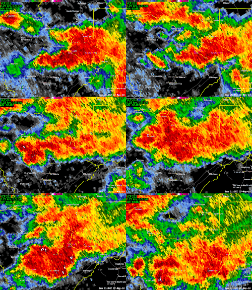
Unfortunately, a second, even heavier round of thunderstorms moved directly over Ellicott City and Catonsville, resulting in a second, more devastating round of flash flooding while search and rescue was underway...
After seeing this second round develop, the NWS issued an even more strongly worded statement:
"At 620 PM EDT, numerous reports of significant flash flooding have been reported, especially in Ellicott City. ANOTHER ROUND OF HEAVY RAIN IS MOVING BACK INTO THIS AREA. EVEN THOUGH RAIN HAS RECENTLY DECREASED, RESPONDERS AND LOCALS WHO ARE IN ELLICOTT CITY MUST RETURN TO HIGHER GROUND IMMEDIATELY! A THIRD ROUND OF FLOODING IS IMMINENT! IF YOU ARE NOT IN THE AREA, STAY AWAY! THIS IS A CATASTROPHIC AND LIFE-THREATENING EXTREMELY DANGEROUS SITUATION! YOU MUST TAKE ACTION NOW AND STAY AWAY FROM ANYWHERE WHERE WATER IS OR COULD BE'!"
The Hudson Branch Stream Gauge
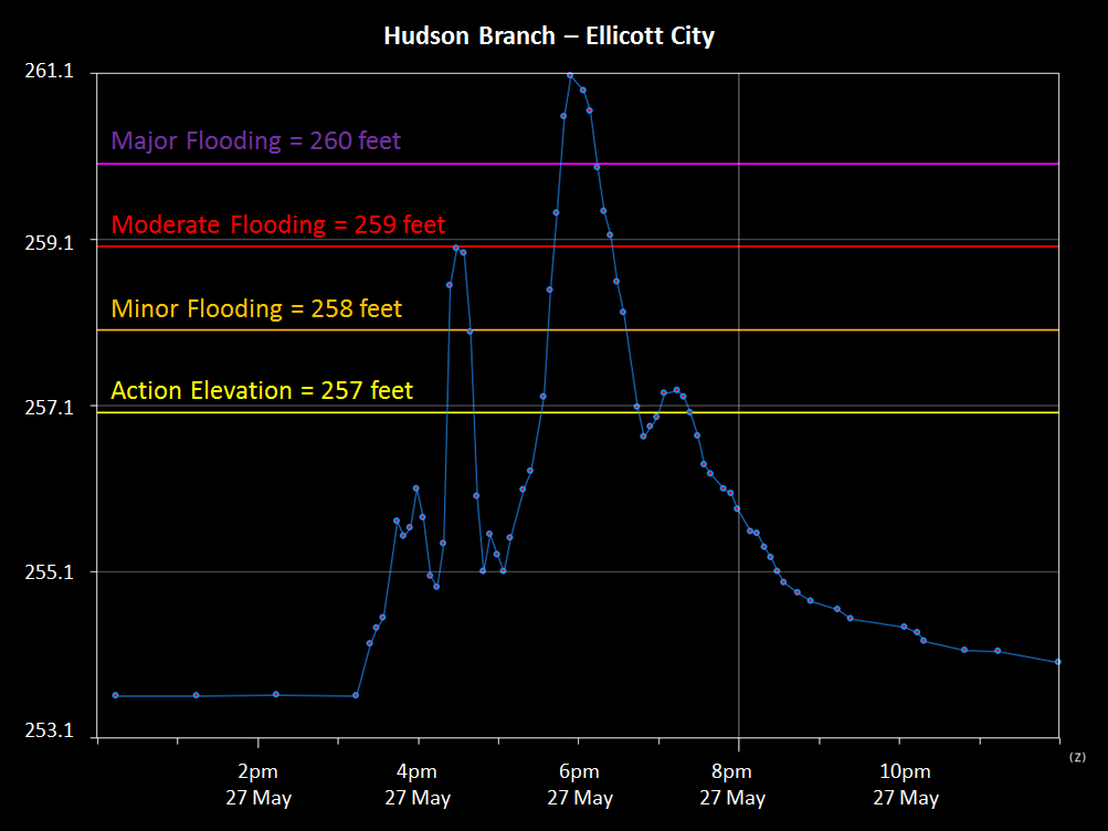
These thunderstorms dropped several inches of rain per hour, resulting in rapid and severe rises along the Patapsco River in Ellicott City. The Hudson Branch went from slightly elevated to moderate flood stage in less than 30 minutes during the first round of flooding. More impressively, the Hudson Branch went from elevated to well past major flood stage in under an hour.
In total, rainfall amounts were fairly similar to what the area experienced in 2016. Most of the county saw rainfall totals in the 2-4" range, and 5-12" over the eastern part of the county around Ellicott City, into western Baltimore County around Catonsville.
NWS Rainfall Totals
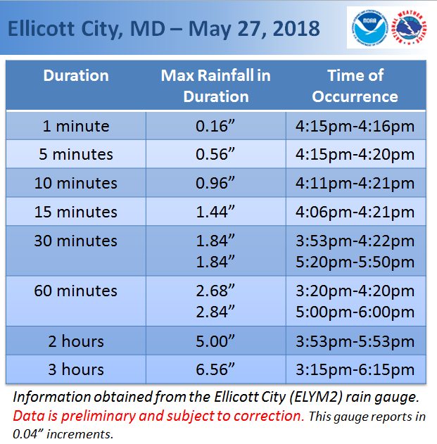
This graphic was shared by the NWS showing just how fast the rain fell, leading to the rapid onset of the catastrophic flash flood:
Impacts
While Maryland is no stranger to flooding, the impacts from this flood on Ellicott City were devastating. Businesses were condemned, homes were ruined, and dozens of cars were destroyed. Water levels rose to more than 8 feet along Main Street, overtopping stop signs along the road, and trapping people in their cars and buildings. But worst of all, Howard County lost one of its own. Eddison Hermond, age 39, tragically died in the flood while attempting to rescue another resident who was trapped. Our hearts go out to the friends and family of Mr. Hermond as we reminisce this somber day in Ellicott City history. We thank him for his service, and for heroically sacrificing his life to save another.
After this round of flooding, Howard County installed outdoor warning sirens in Ellicott City that automatically activate when the NWS issues a flash flood warning for Ellicott City. Additionally, signage and evacuation instructions are posted throughout Main Street to help with evacuations ahead of a flood.
