On the evening of November 2nd, 2018, a powerful EF2 tornado touched down in Mount Airy, resulting in severe damage to trees, power lines, and structures. The tornado formed rapidly within a QLCS with no tornado or severe thunderstorm warning in effect during the time that the tornado was on the ground. Looking back, there probably should have been a tornado warning issued. However, this tornado occured rapidly, and did not last long. Tornadoes that are embedded within these squall lines are hard to warn for, and sometimes go unnoticed. In many cases, by the time a warning is issued, the tornado has already lifted.
Fall and winter tornadoes are uncommon in Maryland, but they do happen, especially when you have an exceptionally dynamic large scale system moving in like this on top of very mild temperatures and spring like humidity. One example of this would be February 7th, 2020, when a half dozen tornadoes touched down across Frederick, Montgomery, Carroll, and Cecil counties early in the morning.
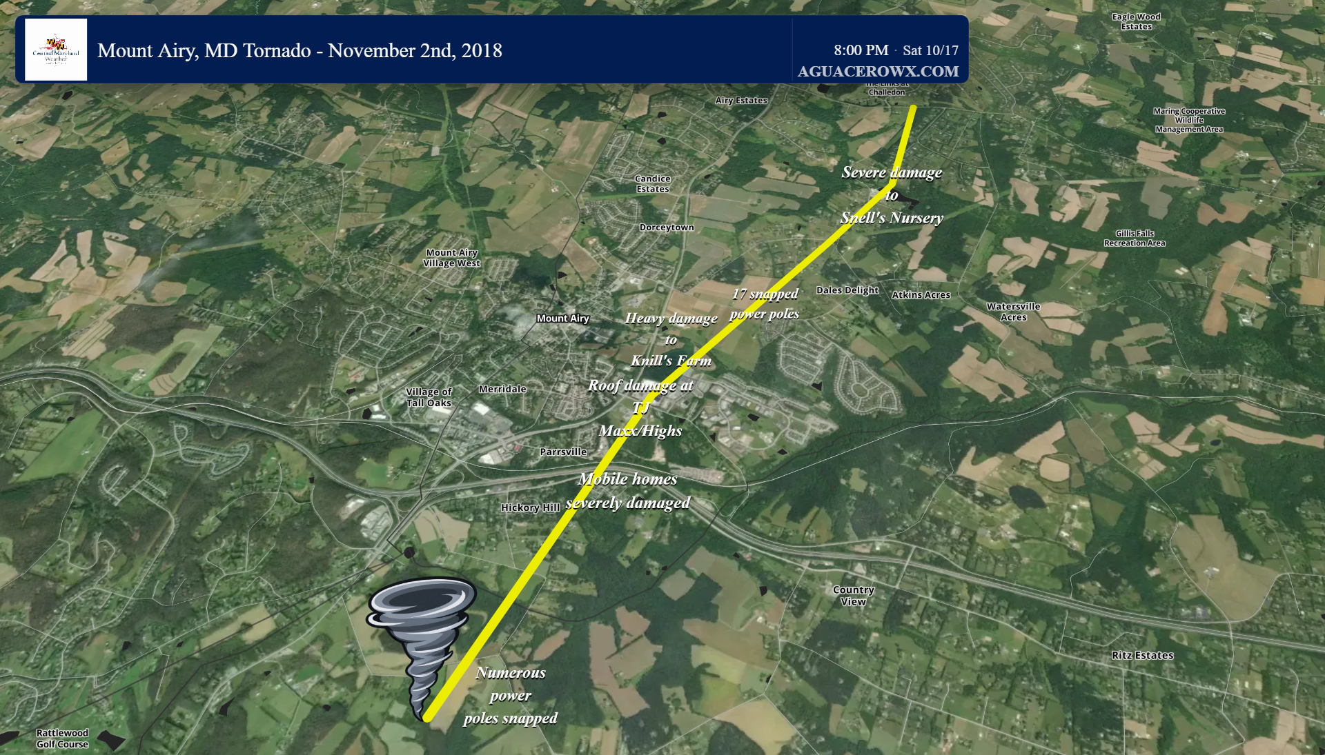
Estimated path of the tornado
Radar Analysis
A line of strong storms with torrential rain and gusty winds was clearly defined stretching from southern PA into northern VA. As this line raced eastward, it interacted with some type of bounadry or terrain induced circulation over central MD and produced a strong EF2 tornado over Mount Airy.
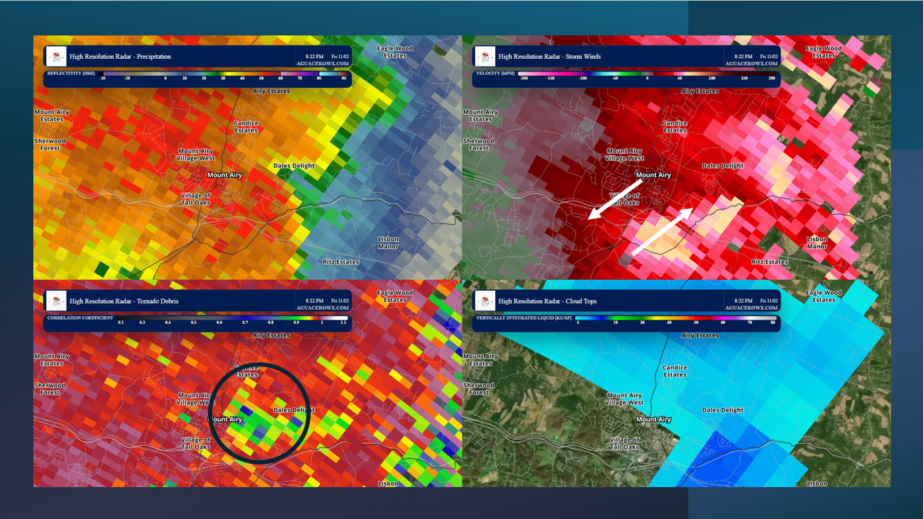
In the 4-panel radar display below, youll see 4 radar products used in detecting severe storms. In the top left, you have reflectivity, which shows precipitation. In the top right, you have velocity, which shows the wind speeds and direction inside the storm. In the bottom left, you have correlation coefficient, which is used to detect the lofting of debris within a tornado. And in the bottom right, are cloud tops, showing how tall the storms are.
You cant see much on reflectivity, as this tornado was embedded within a QLCS (quasi linear convective system), so it was entirely wrapped in rain. However, the velocity data and the correlation coefficient data are very telling. There is a clear and strong velocity couplet, showing strong rotation in the storm. Below that velocity couplet, is a well defined lowering in the correlation coefficient, which indicates a tornado is in progress and is lofting debris. In this case, debris was lofted to over 10,000 feet into the air.
Also notice the cloud tops, or, how tall the storms were. Most severe storms have cloud tops of 40-60 thousand feet, but these had tops less than 30 thousand feet. This is due to the lack of instability (discussed below), and goes to show you don’t need a lot of instability for tornadoes when you have such a dynamic large scale storm system moving in like this. There also was not much lightning with these storms, likely owing to the lower cloud tops and weak instability.
The Environment
The environment in which this tornado formed in was a classic high shear low cape (HSLC) severe weather set up. We see this every year in the cool season, with November being the peak month for this to occur. Warm southerly winds bring in mild air from the south, with temps in the mid 60s even during the evening hours. This led to very meager, but sufficient amounts of instability (storm fuel) developing ahead of the line of storms.
This environment was favorable for QLCS tornado development because of the combination of strong wind shear and exceptionally high low-level storm-relative helicity (SRH), despite relatively weak instability. The sounding shows 35 knots of 0–1 km bulk shear and 66 knots of 0–3 km bulk shear, meaning winds increased significantly with height, both in speed and direction. This is important because wind shear helps organize thunderstorms and provides the environment necessary for rotating updrafts to develop. The 0–1 km SRH of 333 m²/s² and 0–3 km SRH of 551 m²/s² are particularly noteworthy because they indicate a substantial amount of rotation available for storms to ingest, especially near the ground. In simpler terms, the atmosphere had winds changing direction and getting stronger with height, creating an environment where thunderstorms along a squall line could develop rapidly rotating circulations called mesovortices.
Although the wind dynamics were favorable, instability was relatively limited, with only 188 J/kg of surface-based CAPE and 43 J/kg of mixed-layer CAPE. CAPE measures how much energy is available for air parcels to rise and fuel thunderstorms. Higher CAPE generally means stronger potential updrafts, while lower CAPE means thunderstorms have less buoyant energy to work with. However, tornadoes do not necessarily require large amounts of instability when strong wind shear is present. In this case, the exceptionally high low-level SRH provided an environment conducive to developing and strengthening rotation along the squall line, while the low LCL of approximately 38 meters indicated cloud bases extremely close to the ground. Essentially, there was not much energy available to fuel storms, but there was plenty of wind shear and low-level rotation to support tornado development. This is characteristic of a high-shear, low-CAPE (HSLC) environment, which can be particularly favorable for QLCS tornadoes.
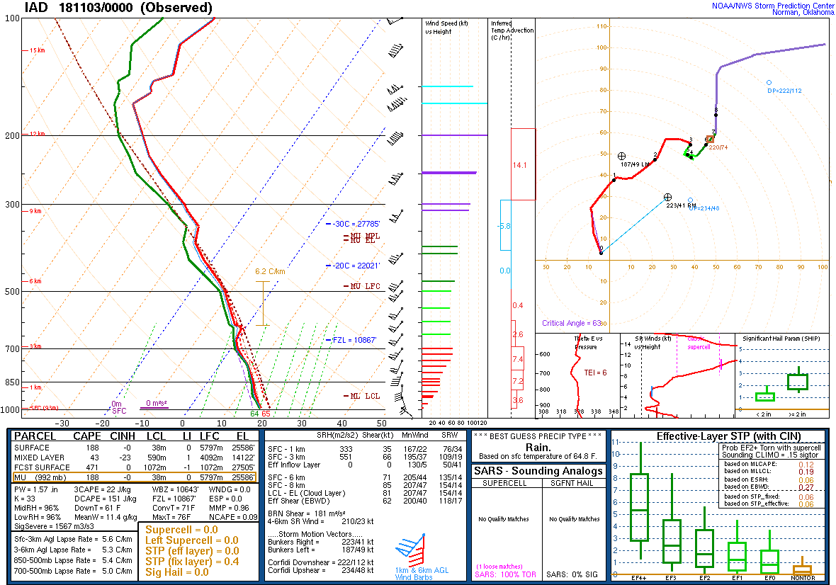
Weather balloon sounding from IAD at 8pm just prior to the tornado
The first area of damage was noted in a wooded area near the intersection of Griffith road and Bennett Road where several trees were blown down. The tornado produced instances of tree damage ranging from EF0-EF1 intensity along its path south of I-70. On Ridge Dr, numerous trees were downed and several mobile homes had significant damage. The tornado then crossed I-70 and began entering the downtown area of Mount Airy.
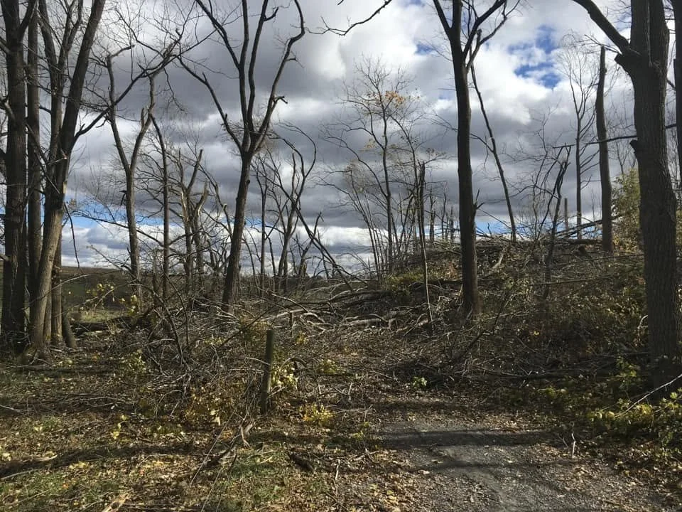
Hardwood trees snapped and uprooted behind the Century Dr water tower; NWS Balt/Wash
In the woods between I-70 and the baseball fields at the Mt Airy Volunteer Fire Department Carnival Grounds, numerous trees were snapped and uprooted. The tornado continued moving northward, striking the Twin Arch shopping center. Here, it blew off part of the canopy the Highs gas station, blew an HVAC off the roof of a HomeGoods, tore of a significant portion of the roofing material at the TJ Max, and snapped dozens of hardwood trees surrounding the water tower behind the shopping center. This is where the first area of EF2 level damage occurred, with nearly all trees in the path either snapped or uprooted. Numerous trees were also uprooted between Aaron Ln and Back Acre Circle. Several mobile homes on Mathis Ln suffered minor roof damage.
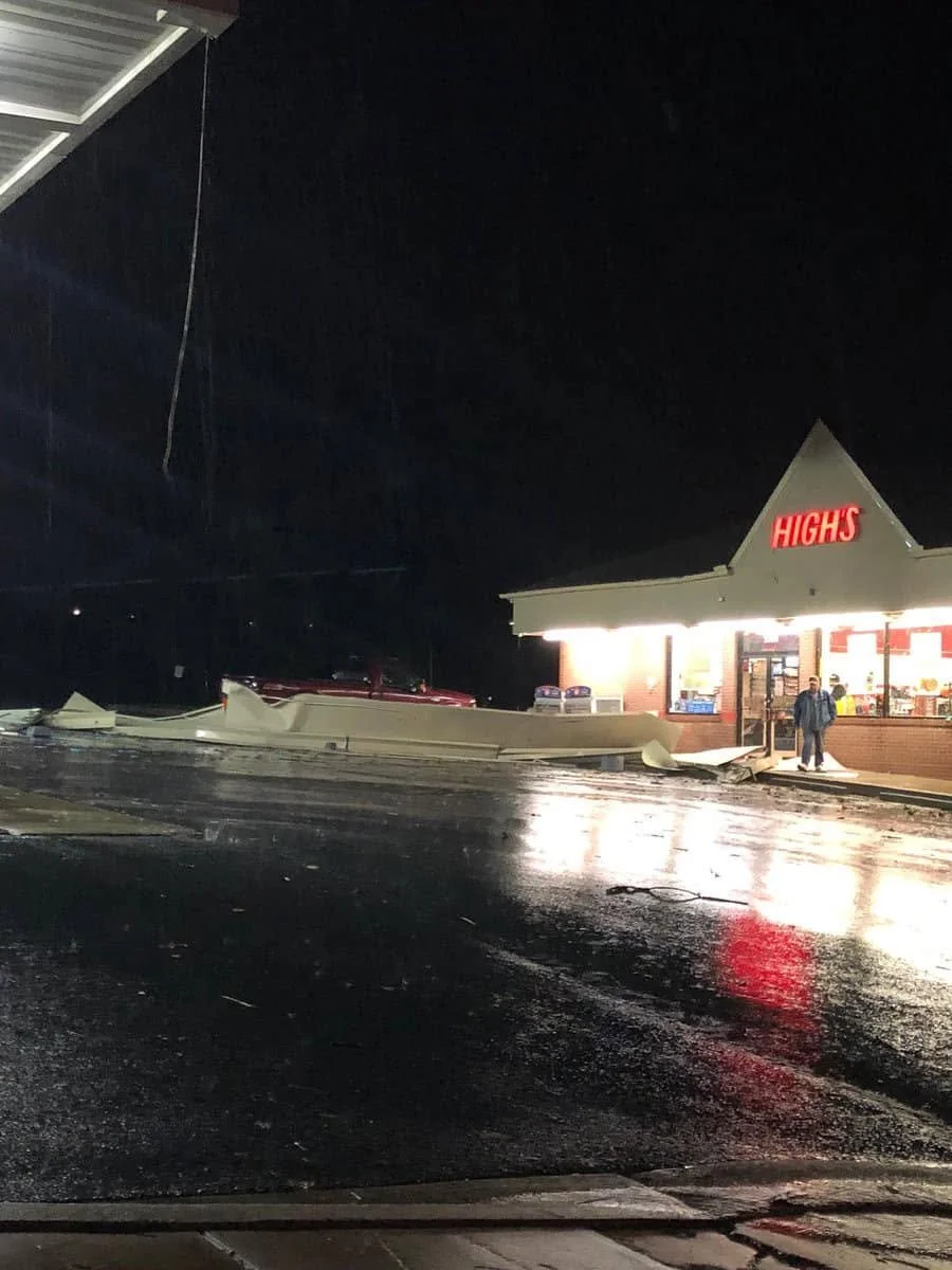
Portion of the canopy torn off at the High’s Gas Station; NWS Balt/Wash
The tornado then struck the Nottingham and Knill’s Farm area. At Knill’s Farm, major damage was sustained to several buildings with several structures having portions of the roofs blown off, and a grain bin was partially collapsed. A mid-sized shed on a side road between the farm and Arrowwood Circle was destroyed, and numerous power poles were snapped along Watersville Road. This is the 2nd area where EF2 level damage occurred. In the Nottingham community, numerous trees were snapped and uprooted along Arrowwood Circle, Cobblestone Ln, Crossbow Rd, and Longbow Rd. In addition, a few houses had shingles and facia blown off from the wind.
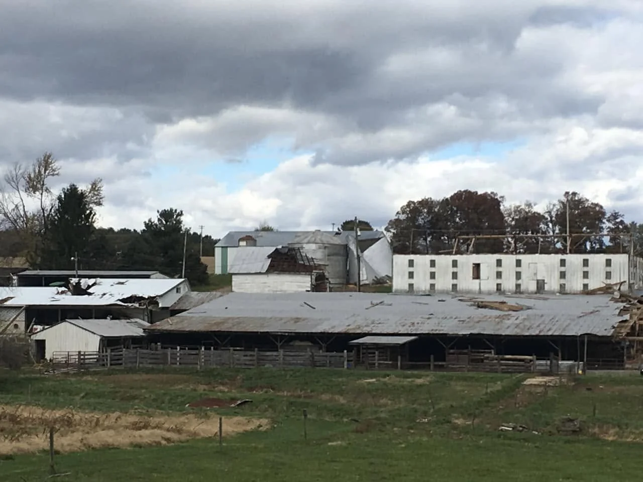
Distant shot of the damage at Knill’s Farm Market; NWS Balt/Wash
Next, the tornado began impacting Boteler and Runkles Roads. On Boteler road, a house suffered substantial roof damage, and powerlines were snapped. Near the intersection of the 2 roads, numerous trees were snapped and uprooted. The tornado then hit Snell’s Nursery, where another area of EF2 level damage occurred. Numerous trees were snapped, greenhouses were destroyed, and a pond was sucked dry. In addition, a nearby weather station recorded a 112mph wind gust.
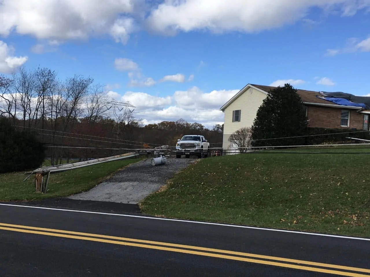
Snapped power pole along Boteler Road along with roof damage; NWS Balt/Wash
The tornado began to weaken behind Heavenly Cause Ct, but not before snapping additional trees along the way. The last area of damage occurred on Gillis Falls Road, where large branches were snapped before the tornado dissipated.
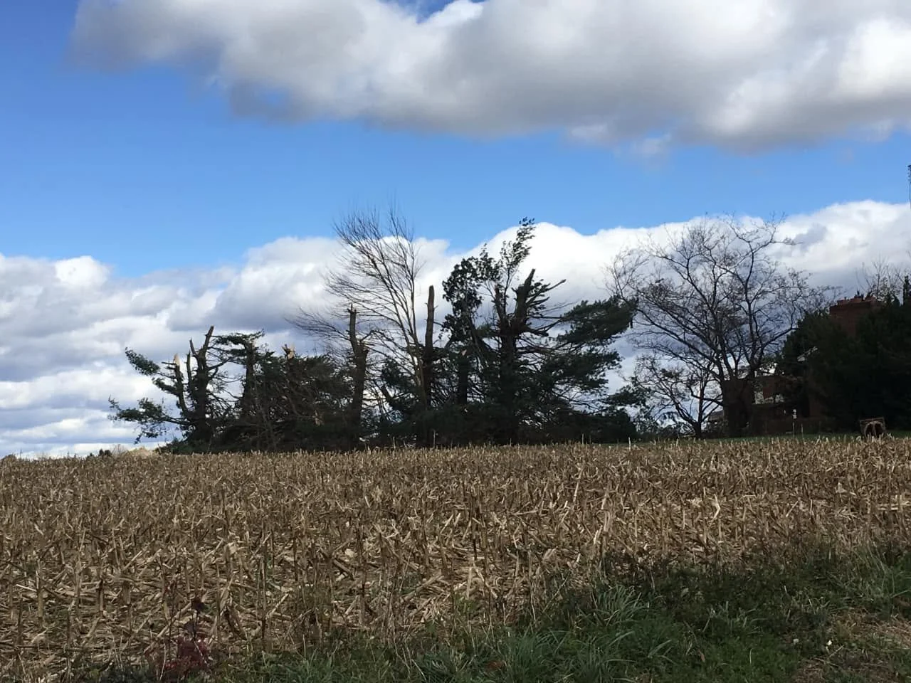
Large pine trees snapped in half off Watersville Rd; NWS Balt/Wash
In total, the tornado produced a damage path of just over 4.5 miles, and had a maximum width of approximately 1/2 mile wide, making it one of the largest tornadoes to ever occur anywhere in Maryland. The tornado was rated EF2 with maximum winds of around 120mph by the National Weather Service. It was the strongest tornado to strike Carroll County since the mid 90s. The only other tornado of this magnitude since 2018 to strike Carroll County was an EF2 on June 5th 2024 in Eldersburg.
As the squall line contniued east, it also produced an EF-1 tornado in Dundalk, killing 2 Amazon employees when a wall from the warehouse collapsed as it was struck by the tornado. This was the deadliest MD tornado since 2002 when La Plata was stuck by a violent EF4 tornado.
