OTD IN 2025: catastrophic flash flood claims the life of young mount airy resident
On the afternoon of July 31st, 2025, intense thunderstorms with 8" per hour instantaneous rainfall rates stalled along the I-70 corridor stretching from Baltimore to Frederick. Directly under this band of storms sat Mount Airy. In less than 90 minutes, more than 4" of rain fell on the town, resulting in a severe flash flood that tragically took the life of 13 year old Mason Kearns, a resident of Mount Airy. We mourn the loss of this young man, and keep his family in our thoughts.
Radar Analysis and NWS Alerts
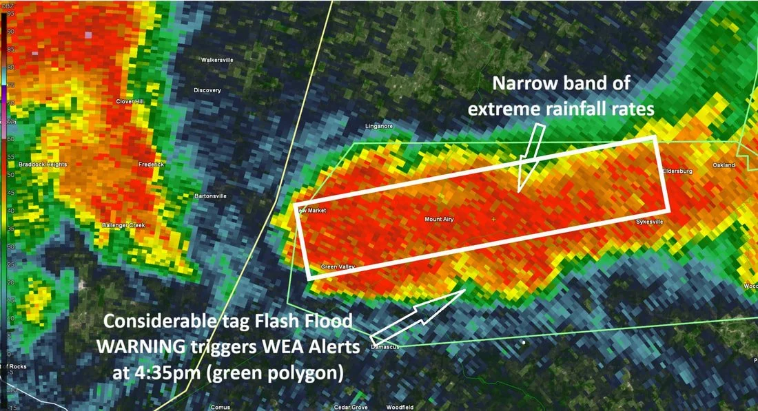
Thunderstorms started off very scattered, with hardly any activity in the vicinity of Mount Airy for much of the afternoon. However, outflow boundaries, which is basically cool air exiting the thunderstorm, from 2 thunderstorms collided directly over the town, resulting in the rapid development of new and now stationary thunderstorms right over southern Carroll County and eastern Frederick County. In a highly unstable and very moist environment, the thunderstorms were able to sustain themselves for more than an hour over the same location, which is somewhat unusual. While not scientifically proven in our case, Parr's Ridge may have played a role in the longevity of these storms, as mountains aid in lift, which is necessary for thunderstorm development.
These thunderstorms produced tremendous rainfall rates thanks to a moisture loaded atmosphere, with peak instantaneous rainfall rates as high as 8" per hour being recorded. This quickly prompted the issuance of a Flash Flood Warning for much of the area under these storms, including all of Mount Airy. This is what is known as a "Base Tag" Flash Flood Warning, which does not trigger Wireless Emergency Alerts (WEA) on our cellphones.
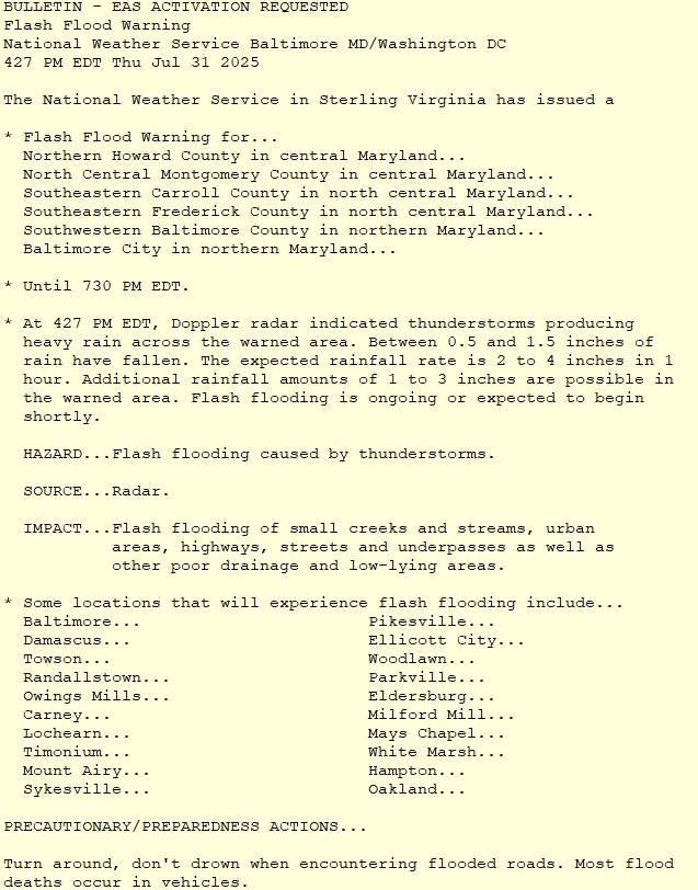
Once reports of substantial flash flooding arrived, the National Weather Service upgraded the warning to a "Considerable Tag", which is used when widespread or considerable flash flooding is expected. Even places that don't normally flood could experience flash flooding in this type of event. This poses an immediate threat to life and property for those living in or near low lying areas, and will automatically activate Wireless Emergency Alerts on cellphones. This is the second highest level of flash flood warning that can be issued (second only to the highest tier which is a flash flood emergency, issued when catastrophic flash flooding is already ongoing), and is used only when there is high confidence in significant flash flooding that is imminent or already ongoing.
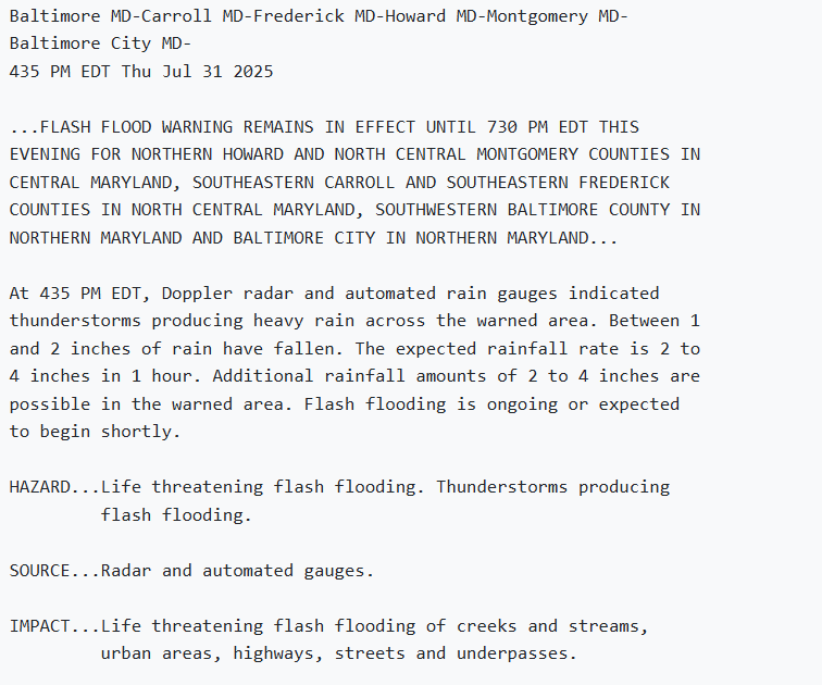
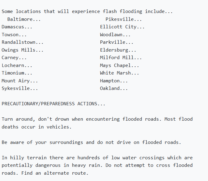
Note that the hazard description changes from "flash flooding caused by thunderstorms" to "life threatening flash flooding". Also take note of the mention of how hilly terrain has an impact on the flooding. In hilly terrain such as what we have in Mount Airy, low water crossings present another challenge to people who are outdoors or traveling, since they can rapidly flood far more easily than most areas.
What Changed After This Tragedy?
After devastating flooding in Texas, and now our own flash flood tragedy, and our history of tornadoes (2018, 2012, etc), it was clear that our town was in need of a way to alert residents outdoors of impending life threatening weather conditions. Not just your run of the mill thunderstorm, but high end flash flooding, destructive winds, and tornadoes.
The Mount Airy Inclement Weather Task Force was formed in August of last year to assess what could be done to make sure the town doesn't lose a single other resident or visitor in a natural disaster ever again.
In October of last year, Mason's Law was passed in honor of Mason, requiring the inspection of storm drains all across Maryland, and requiring the install of grates over those that posed a risk of drowning. After several months of research, analysis, and discussion, the Task Force came to the conclusion that a set of Outdoor Warning Sirens was a needed system to alert those who are outdoors that they need to immediately move to a safe location and check local media for information on an impending life threatening weather threat.
In January of this year, the Town Council voted unanimously to allow the install of this system, and the Task Force is committed to raise at least 50% of the total cost of the system, with the goal of having it installed and operational by the end of the year. These sirens, in addition to cellphone WEA alerts, weather radios, and TV broadcasts will help keep the residents, businesses, and visitors of the town safe when severe weather strikes.
Our hope is that we will never have to use the sirens. But the reality is, we probably will. With the changing climate, storms are becoming more severe, and flooding is becoming more common. And so, it is crucial to have them in place for when our town is inevitably in the line of dangerous severe weather.
Flash Flood Safety
It is important to learn the difference between a flood WATCH and a flash flood WARNING. When a flash flood WATCH is issued, it means that thunderstorms will be capable of producing enough rain in a short amount of time that could cause flash flooding. When a flash flood WARNING is issued, it means that flash flooding is expected to begin shortly, or is already ongoing.
When a flash flood warning is issued, you should avoid travel. While you may live in an elevated non flood prone area, there may be locations along your route that are flooded. If you live in a flood prone area, and the flooding has not yet begun, you should evacuate and move to higher ground right away. If the flooding has already begun, you should move as high as you can i your home or business.
NEVER drive through a flooded roadway. It takes just 6 inches of flowing water to sweep an adult off their feet, and just 12" to float a car. In many cases, it is impossible to tell the depth of the water, and even worse, if the road below is washed out or unstable. Most flood deaths in the United States occur in vehicles. Remember this phrase: Turn Around, Don't Drown!
